

Met Office extends yellow weather warning for snow and ice by a further 48 hours; alert, which covers Highland, Moray, Aberdeenshire, Angus and Fife will stay in force until Sunday
Register for free to read more of the latest local news. It's easy and will only take a moment.

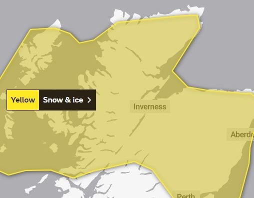
A YELLOW weather warning for snow which was originally only in place for Wednesday before being extended, has been extended yet again - and will now remain in force right through the weekend.
The latest warning period has been extended by 48 hours, and will now end at midday on Sunday. It was previously due to end at the same time on Friday.
The extension to the snow and ice warning comes after parts of the Highlands, Moray and Aberdeenshire experienced heavy snow overnight. Highlands & Islands Weather (@highlandweather on Twitter, and Highlands and Islands Weather on Facebook) was reporting depths of up to 18cm in the Tomintoul area, while on the west coast, 6cm was reported in the hills around Ullapool. Other parts of Wester Ross were also badly affected by the weather, with Highland Council reporting that schools in Gairloch and Poolewe were closed due to the treacherous conditions.
Seven centimetres was also reported in parts of Sutherland.
Trains travelling between Inverness and Aberdeen were badly affected by disruption on Thursday morning after heavy snow between Huntly and Insch caused signalling faults. These have now been cleared, but ScotRail warned that knock-on disruption will continue to affect services until 3pm.
The newly-extended yellow warning covers the Highlands, Moray, Aberdeenshire, Skye, the Small Isles and the Outer Hebrides, although Orkney and Shetland – which had been part of the original alert – are no longer included in the 'at risk' areas. Angus and Fife are also covered by the warning.
Read more: Van leaves road in snowy conditions on A835 between Garve and Ullapool
Read more: Badenoch and Strathspey roads condition report
Read more: Heavy snow sparks train cancellations, warns ScotRail
A Met Office spokesman said: "Showers will fall as snow to low levels at times. Accumulations of 2-5 cm are possible at lower levels, with 10-15 cm above 200 metres, especially across North Highland, Moray and Aberdeenshire.
"Some drifting and blizzard conditions are possible on hill routes at first. In addition, ice is likely to form on untreated surfaces, mainly where some of the showers fall as rain or sleet on some coasts."