

WATCH: Storm Babet warning upgraded to amber by Met Office
Register for free to read more of the latest local news. It's easy and will only take a moment.

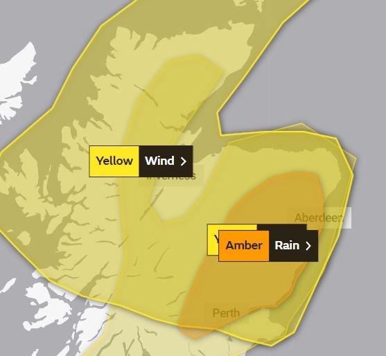
Storm Babet now looks set to impact more Highland communities later this week after weather warning areas were extended by the Met Office.
Forecasters are now predicting a larger part of the region will face a potentially damaging deluge and associated flooding.
And a separate warning elsewhere in Scotland for even heavier rain has been upgraded to an amber alert.
A yellow warning for heavy rain will come into force in the Highlands at 6am on Thursday and remain in place until 6am on Saturday.
Related: Storm Babet flood warning for Highlands sparks plea to be prepared
The alert, which originally only covered Caithness and eastern Sutherland, now extends south into Ross-shire and down past the Great Glen and on into central and southern Scotland.
It has also been extended north and eastwards from Badenoch into Moray, as well as out across all of Aberdeenshire, Angus and Fife.
However, Inverness and most of the Black Isle are not included in this rainfall alert.
Rainfall totals of up to 100mm are possible.
A Met Office spokesman said: "While there is still some uncertainty in detail, there is the potential for periods of heavy, prolonged and potentially disruptive rainfall to develop on Thursday and perhaps continue into Saturday across parts of the area.
"Widely 20 to 40mm of rain is expected, but some upland areas of northern England and Scotland could see as much as 70-100 mm of rain. A separate Amber warning is in place for parts of eastern Scotland where higher rainfall amounts are likely to cause greater impacts. The rain will be accompanied by very strong southeasterly winds across parts of Scotland, which could exacerbate impacts.
A separate rain warning, which originally extended westward from the east coast as far as Aviemore, has now been revised and no longer quite reaches Badenoch and Strathspey. However, it does extend across Pitlochry in the south, so A9 motorists travelling too and from the Highlands will need to take added care.
This alert runs from 6am on Thursday to 6pm on Friday and could bring up to 200mm of rainfall in places.
Commenting on the area covered by the amber alert, a Met Office spokesman added: "Widely 70-100 mm of rain is likely, but some upland areas may see as much as 150-200 mm of rain through this period. Very strong southeasterly winds are likely to accompany heavy rainfall which may exacerbate impacts."
Meanwhile, a third weather warning – this time for gale force winds – will be in force from 3am on Thursday until midday on Friday and covers most of northern Scotland's mainland as well as the Northern Isles.
Gusts of up to 80mph are possible, warn forecasters. A spokesman added: "Gusts to 40-50 mph can be expected quite widely within the warning area, but coastal eastern Scotland and Orkney could see gusts 60-70 mph. Some locations over and to the lee of mountains across northwest Scotland could encounter sudden gusts in excess of 80 mph for a time. Large waves will be an additional hazard around North Sea coasts."