

Storm Babet sparks rare red 'danger to life' warning from Met Office as north and east Scotland brace for deluge
Register for free to read more of the latest local news. It's easy and will only take a moment.


Storm Babet's impact on northern and eastern Scotland is expected to be more intense than originally predicted – after the Met Office upgraded warnings in the far north to amber, and increased an earlier alert over the Grampians to red.
It has warned residents living in Caithness, Sutherland and Ross-shire that rainfall totals in excess of 100mm are now thought possible in those areas – prompting a decision on Wednesday morning to increase an earlier yellow warning to amber.
This alert runs from 6pm on Thursday until 9am on Friday, and stretches down the east coast from Caithness in the north to near Beauly in the south.
A Met Office spokesman said: "A period of heavy and prolonged rainfall is expected to bring some disruption to parts of northern Scotland. The heaviest rain is expected to be across Easter Ross, eastern parts of Sutherland and Caithness.
"Widely 50 to 80mm of rain is expected to fall within a 12 to 24 hour period with around 100mm in upland areas. Strong east or southeasterly winds are likely to accompany heavy rainfall which may exacerbate impacts."
A wider yellow warning for heavy rain extending from Caithness in the north, south through the Great Glen and on into southern Scotland – and also north and east through Badenoch and Strathspey into Moray – also remains in place. This will be in force from 6am on Thursday until 6am on Saturday.
Related: Highland Council roads team 'put on stand-by' ahead of Storm Babet
Related: WATCH: Storm Babet warning upgraded to amber by Met Office
However, the areas expected to be worst affected by rainfall during Storm Babet are parts of southern Aberdeenshire and Angus – where the Met Office has now taken the rare decision to issue a red weather warning, indicating a potential 'danger to life'.
Issuing its revised red warning for those areas, a Met Office spokesman said: "There is now high confidence in exceptional rainfall falling across southeast Grampian, particularly the uplands of Angus and south Aberdeenshire.
"100-150 mm of rain is expected to fall widely within 24 hours with some locations likely to see 200-250 mm of rain which is expected to cause considerable impacts both where it falls and lower lying areas further east."
The red alert runs from 6pm on Thursday to midday on Friday.
A third rain warning – this one amber – also remains in place over an area stretching from the Firth of Forth in the south to north Aberdeenshire in the north, and westward into the Cairngorms National Park. It will be in force from 6am on Thursday until 6pm on Friday.
There have also been two wind warnings issued for northern and eastern Scotland in relation to Storm Babet.
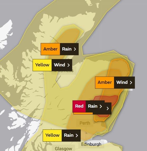
A yellow warning for the far north was revised on Wednesday morning, amid predictions that wind speeds could be stronger in some areas.
This warning, which predicts gusts of up to 80mph in northwest Scotland on leeward sides of mountains – and gusts of 65mph widely across parts of Caithness, Sutherland, Ross-shire, Inverness-shire and beyond – runs from 3am on Thursday until midday on Friday.
A separate wind warning for eastern Scotland covering Aberdeenshire and Angus's coasts has also been upgraded to amber.
A Met Office spokesman said: "Gusts to 40-50 mph can be expected quite widely within the warning area, but Orkney and coastal parts of North Highland will likely see gusts of 55-65 mph for a time later on Thursday into early Friday.
"A separate amber warning is in place for eastern areas of Angus and Aberdeenshire where gusts in excess of 70 mph are possible for a time on Thursday. Some locations over and to the lee of mountains across northwest Scotland could encounter sudden gusts in excess of 70-80 mph for a time. Large waves will be an additional hazard around North Sea coasts."
The amber wind warning will run from 10am on Thursday until 6pm the same day.