

Highland residents warned of further snow after another yellow alert was issued by the Met Office
Register for free to read more of the latest local news. It's easy and will only take a moment.

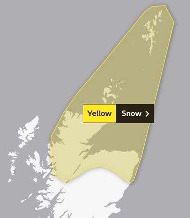
ANOTHER snow warning has been issued by the Met Office for much of the Highlands overnight tonight.
Its latest yellow alert comes into force at 7pm on Tuesday and will remain in effect until 10am on Wednesday.
Forecasters are warning that snow and hail showers will fall even down to sea level, and that strong winds could spark drifting and lead to local transport disruption.
The latest warning comes after many parts of Sutherland experienced snow overnight, with as much as two inches falling in some places – and drifting affecting some of the highest routes.
Describing tonight's yellow warning, a Met Office spokesman said: “The cold northerly airflow will bring further snow and hail showers across much of northern Scotland. Snow amounts of around one to three centimetres are likely at all levels and, in addition, strong winds will lead to some drifting.
“Showers will become both lighter and less frequent through Wednesday morning.”
The warning covers Inverness, the Black Isle, Loch Ness, the Monadhliath Mountains, all of Caithness and Sutherland, virtually all of Ross-shire, and the Northern Isles. It also extends east through much of Moray and Aberdeenshire.
For the latest updates, visit the Met Office’s weather warnings webpage.
Related news: Snow patrols out again in Badenoch and Strathspey
Related news: More snow sparks second yellow Met Office warning